


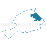
Hollybrook Voting District, Bland County, Virginia
About
Outline

Summary
| Unique Area Identifier | 681175 |
| Name | Hollybrook Voting District |
| County | Bland County |
| State | Virginia |
| Area (square miles) | 31.05 |
| Land Area (square miles) | 30.97 |
| Water Area (square miles) | 0.08 |
| % of Land Area | 99.76 |
| % of Water Area | 0.24 |
| Latitude of the Internal Point | 37.20239930 |
| Longtitude of the Internal Point | -80.97914380 |
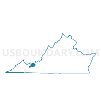
Maps

Graphs
Select a template below for downloading or customizing gragh for Hollybrook Voting District, Bland County, Virginia


Neighbors
Neighoring Voting District (by Name) Neighboring Voting District on the Map
- Mechanicsburg Voting District, Bland County, VA
- Rocky Gap Voting District, Bland County, VA
- Seddon Voting District, Bland County, VA
- White Gate Voting District, Giles County, VA
Top 10 Neighboring County Subdivision (by Population) Neighboring County Subdivision on the Map
- Central district, Giles County, VA (5,917)
- District 2, Bland County, VA (1,754)
- District 3, Bland County, VA (1,727)
- District 4, Bland County, VA (1,569)